


3D scanning
Photometric uses high‑precision laser scanning to bring reality into the digital space: we create detailed 3D point clouds consisting of millions of measured points, providing a reliable foundation for engineering models, 2D evaluations and complex infrastructure‑development projects.
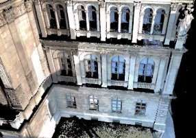
the Hungarian Academy of Sciences
What is laser scanning?
One of the most efficient and most advanced methods of spatial data acquisition is so‑called laser scanning.
A laser scanner can measure the spatial coordinates of several million points within just a few seconds with high accuracy. The result of the survey is a three‑dimensional “point cloud”, from which the geometric data of the scanned objects can be extracted through post‑processing.
How does a laser scanner work
Its operating principle is similar to that of a total station. Using a laser beam, the instrument measures the distance between the scanner and each point. Because the scanner also records the direction of the laser beam (horizontal and vertical angles), the 3D coordinates of the measured points can be calculated relative to the scanner’s position.
A key difference is that while traditional surveying methods can measure only a few points per minute, a laser scanner determines the coordinates of millions of points — the laser beam essentially “sweeps” and scans its surroundings.

When is it worth choosing 3D scanning technology?
Based on the nature, scale, accuracy requirements, time constraints and budget of a given project, it is usually possible to clearly determine which method — photogrammetry, traditional geodetic surveying, laser scanning, or a combination of these — is the most appropriate for the user.
The various measurement methods generally complement each other well, but to achieve the required accuracy and reliability, photogrammetric workflows and 3D scanning alike typically require control points established with a geodetic total station.
The following table summarizes some key characteristics of the surveying technologies we use.
|
Geodesy |
3D scanner |
Photogrammetry |
|
|
Data volume (per project) |
Typically a few thousand 3D points. |
Many millions of directly measured 3D points. |
Many millions of 2D points, and the corresponding 3D points computed from them. |
|
Accuracy (order of magnitude) |
As little as a few millimetres. |
Typically 1–2 cm. |
Typically a few centimetres. |
|
Gyorsaság |
Field measurement: slow. Office processing: slow. |
Field measurement: medium. Office processing: medium. |
Field measurement: fast. Office processing: medium. |
Our laser‑scanning related services
Laser‑scanner survey
If a given task can be carried out more efficiently (and at lower cost) using laser scanning than with photogrammetric or traditional geodetic methods, we recommend this technology to our clients.
In such cases, the field survey is performed together with any necessary supplementary geodetic measurements and photogrammetric captures.
Processing of laser‑scanner survey data
Point‑cloud operations, creation of 3D models, and 2D evaluation (e.g., façade drawings, section drawings).
Orthophoto production
Using laser‑scanned data (3D point clouds).
Ready to bring your project to life?
Contact us and request a personalised quote for our engineering‑precision solutions.